Please use this identifier to cite or link to this item:
http://dx.doi.org/10.25673/60539Full metadata record
| DC Field | Value | Language |
|---|---|---|
| dc.contributor.other | Müller, Johann Carl | - |
| dc.contributor.other | Johann Carl Müllers Buch- und Kunsthandlung | - |
| dc.date.accessioned | 2022-01-27T07:09:52Z | - |
| dc.date.available | 2022-01-27T07:09:52Z | - |
| dc.date.issued | 1790 | - |
| dc.identifier.uri | https://opendata.uni-halle.de//handle/1981185920/62490 | - |
| dc.identifier.uri | http://dx.doi.org/10.25673/60539 | - |
| dc.description.sponsorship | Die Digitalisierung wurde durch die Deutsche Digitale Bibliothek im Rahmen des von der Beauftragten der Bundesregierung für Kultur und Medien (BKM) geförderten Programms NEUSTART KULTUR ermöglicht. | - |
| dc.format.extent | 1 Karte; 34 x 42 cm, auf Blatt 53 x 74 cm | - |
| dc.format.extent | Kupferstich | - |
| dc.language.iso | ger | - |
| dc.publisher | in Johann Carl Müllers Buch und Kunsthandlung | - |
| dc.rights.uri | https://creativecommons.org/licenses/by/4.0/ | - |
| dc.subject.ddc | 090 | - |
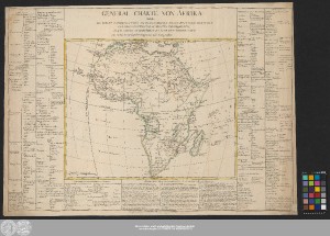
| dc.title | General Charte Von Afrika : welche Die Haupt Landschaften Enthælt, Woraus Dieser Welttheil Bestehet, Und Ihre Eintheilung In Staaten Und Provinzen, Nebst Sowohl Merckwürdigen Als Nuzbaren Anmerckungen / vom Hr. Brion Koeniglichen Ingenieur und Geographen | - |
| dc.type | Map | - |
| dc.identifier.urn | urn:nbn:de:gbv:3:3-1192015415-1688635572-12 | - |
| dc.identifier.shelfmark | Altkt B II 2 [8] 3 | - |
| local.openaccess | true | - |
| dc.identifier.ppn | 1688635572 | - |
| local.comment.extern | Koloriert | - |
| local.mets.uri | https://opendata.uni-halle.de/retrieve/c31a7451-8bf2-4de1-93b7-3b2958c6392e/mets.xml | - |
| local.holding | Universitäts- und Landesbibliothek Sachsen-Anhalt | - |
| local.holding.displayform | Universitäts- und Landesbibliothek Sachsen-Anhalt, Altkt B II 2 [8] 3 | - |
| dc.contributor.cartographer | Brion de la Tour, Louis | - |
| dc.date.digitization | 2022 | - |
| dc.description.note | Nullmeridian: Ferro. - Maßstab in grafischer Form (Stunde) | - |
| dc.description.note | Bergzeichnung | - |
| dc.description.note | Altkarte | - |
| cbs.contenttype.code | cri | - |
| cbs.contenttype.text | kartografisches Bild | - |
| cbs.digitization.displayform | Halle (Saale) : Universitäts- und Landesbibliothek Sachsen-Anhalt, 2022 | - |
| cbs.publication.displayform | Leipzig : in Johann Carl Müllers Buch und Kunsthandlung, [circa 1790] | - |
| cbs.picatype | Aa | - |
| local.map.scale | Circa 1:23 100 000 | - |
| local.map.scale_sort | 1:23100000 | - |
| local.map.coordinates | W 023 00 00-E 062 00 00/N 037 30 00-S 035 00 00 | - |
| Appears in Collections: | Karten und Atlanten | |
Ressources:
 |
|