Please use this identifier to cite or link to this item:
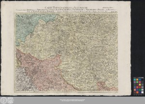
http://dx.doi.org/10.25673/59624| Title: | Carte Topographique D'Allemagne Contenant la heute Silesie savoir les Principautes d'Oppeln, Ratibor, Troppau et Iægerndorf les Seigneuries de Plesen et de Beuten et une Partie du Margraviat de Morawie / Fait par I.W. Iaeger |
| Part: | Feuille XLV |
| Other: | Jaeger, Johann Wilhelm Abraham |
| Published: | À Francfort sur le Mein : se vend chés l'Auteur ; Frankfurt am Main, [1789] |
| Publication place: | Frankfurt am Main |
| Scale: | Circa 1:220 000 |
| Extent: | 1 Karte auf 2 Blättern; 46 x 77 cm Kupferstich |
| Annotations: | Maßstab in grafischer Form (Lieues d'Allemagne) Kopftitel. - Maßstab oben rechts auf dem Kartenrand Mit Bergstrichen "avec P.d.S.M.I." Altkarte |
| Note: | Koloriert; Erweiterungsblatt fehlt |
| Language: | French |
| Online Edition: | Halle (Saale) : Universitäts- und Landesbibliothek Sachsen-Anhalt, 2022 |
| Original Publication: | Universitäts- und Landesbibliothek Sachsen-Anhalt, Altkt D II 2 [1] 6 |
| URN: | urn:nbn:de:gbv:3:3-1192015415-242480268-14 |
| URI: | https://opendata.uni-halle.de//handle/1981185920/61575 http://dx.doi.org/10.25673/59624 |
| Open Access: |  Open access publication Open access publication |
| License: |  Creative Commons Attribution 4.0") (CC BY 4.0) Creative Commons Attribution 4.0 (CC BY 4.0) Creative Commons Attribution 4.0 |
| Sponsor/Funder: | Die Digitalisierung wurde durch die Deutsche Digitale Bibliothek im Rahmen des von der Beauftragten der Bundesregierung für Kultur und Medien (BKM) geförderten Programms NEUSTART KULTUR ermöglicht. |
| Appears in Collections: | Karten und Atlanten |
Ressources:
 |
|