Please use this identifier to cite or link to this item:
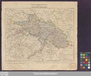
http://dx.doi.org/10.25673/59615| Title: | Post- Und Eisenbahn-Karte Der Provinz Schlesien / Zeichnung v. Cond. Nowack ; Stich v. H. Mahlmann |
| Publisher / Printer: | Carl Heymann |
| Other: | Mahlmann, Heinrich |
| Published: | In Berlin : Verlag von Carl Heymann, [circa 1850] |
| Scale: | 1:200 000 |
| Coordinates: | E 12°58'00"-E 19°34'30"/N 52°14'30"-N 49°10'30" |
| Extent: | 1 Karte; 30 x 39 cm Lithografie |
| Annotations: | Maßstab in grafischer Form (Meilen) Mit Bergstrichen Altkarte |
| Note: | Koloriert |
| Language: | German |
| Online Edition: | Halle (Saale) : Universitäts- und Landesbibliothek Sachsen-Anhalt, 2022 |
| Original Publication: | Universitäts- und Landesbibliothek Sachsen-Anhalt, Altkt D I 4 [7] 3 |
| URN: | urn:nbn:de:gbv:3:3-1192015415-1786737949-11 |
| URI: | https://opendata.uni-halle.de//handle/1981185920/61566 http://dx.doi.org/10.25673/59615 |
| Open Access: |  Open access publication Open access publication |
| License: |  Creative Commons Attribution 4.0") (CC BY 4.0) Creative Commons Attribution 4.0 (CC BY 4.0) Creative Commons Attribution 4.0 |
| Sponsor/Funder: | Die Digitalisierung wurde durch die Deutsche Digitale Bibliothek im Rahmen des von der Beauftragten der Bundesregierung für Kultur und Medien (BKM) geförderten Programms NEUSTART KULTUR ermöglicht. |
| Appears in Collections: | Karten und Atlanten |
Ressources:
 |
|