Please use this identifier to cite or link to this item:
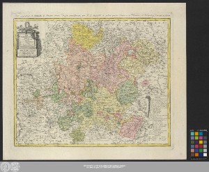
http://dx.doi.org/10.25673/58119| Title: | Der Fraenkische Kreis / von F.L. Güssefeld ; I.M. Schmidt sc |
| Publisher / Printer: | Homannsche Erben |
| Other: | Schmidt, Johann Michael |
| Published: | Nürnberg : bey denen Homaennischen Erben, 1782 |
| Scale: | Circa 1:530 000 |
| Coordinates: | E 8°27'-E 12°26'/N 50°47'-N 48°03' |
| Extent: | 1 Karte; 44 x 54 cm Kupferstich |
| Annotations: | Nullmeridian: Ferro. - Maßstab in grafischer Form (Geographi. Meilen, Stunden) Titel- und Maßstabskartusche links oben. - Erläuterungskartusche rechts unten Mit Bergzeichnung Altkarte |
| Note: | Koloriert |
| Language: | German French |
| Subjects: | Fränkischer Reichskreis |
| Online Edition: | Halle (Saale) : Universitäts- und Landesbibliothek Sachsen-Anhalt, 2022 |
| Original Publication: | Universitäts- und Landesbibliothek Sachsen-Anhalt, Altkt B III 7 [8] 7 |
| URN: | urn:nbn:de:gbv:3:3-1192015415-30381926X-17 |
| URI: | https://opendata.uni-halle.de//handle/1981185920/60070 http://dx.doi.org/10.25673/58119 |
| Open Access: |  Open access publication Open access publication |
| License: |  Creative Commons Attribution 4.0") (CC BY 4.0) Creative Commons Attribution 4.0 (CC BY 4.0) Creative Commons Attribution 4.0 |
| Sponsor/Funder: | Die Digitalisierung wurde durch die Deutsche Digitale Bibliothek im Rahmen des von der Beauftragten der Bundesregierung für Kultur und Medien (BKM) geförderten Programms NEUSTART KULTUR ermöglicht. |
| Appears in Collections: | Karten und Atlanten |
Ressources:
 |
|