Please use this identifier to cite or link to this item:
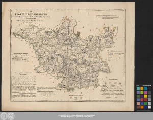
http://dx.doi.org/10.25673/58102| Title: | Die Provinz Brandenburg : in ihrer reinen Begrenzung und der Beschaffenheit ihrer Bodenfläche : entworfen im Jahre 1838 / Steindr. v. C.A. Eyraud in Neuhaldensleben |
| Publisher / Printer: | Müller, Johann Carl Müller'sche Buchhandlung |
| Other: | Eyraud, Carl August |
| Published: | Erfurt : Verlag der J.C. Müller'schen Buchhandlung, [1838?] |
| Scale: | 1:800 000 |
| Coordinates: | E 11°15'-E 16°25'/N 53°47'-N 51°12' |
| Extent: | 1 Karte; 37 x 45 cm Lithografie |
| Annotations: | Maßstab in grafischer Form (geographische Meilen) Mit geognostischen Notizen und geographisch-statistischen Nachrichten Inselkarte Altkarte |
| Language: | German |
| Subjects: | Brandenburg Wirtschaft |
| Online Edition: | Halle (Saale) : Universitäts- und Landesbibliothek Sachsen-Anhalt, 2022 |
| Original Publication: | Universitäts- und Landesbibliothek Sachsen-Anhalt, Altkt D II 4 [2] 2 |
| URN: | urn:nbn:de:gbv:3:3-1192015415-240413547-13 |
| URI: | https://opendata.uni-halle.de//handle/1981185920/60053 http://dx.doi.org/10.25673/58102 |
| Open Access: |  Open access publication Open access publication |
| License: |  Creative Commons Attribution 4.0") (CC BY 4.0) Creative Commons Attribution 4.0 (CC BY 4.0) Creative Commons Attribution 4.0 |
| Sponsor/Funder: | Die Digitalisierung wurde durch die Deutsche Digitale Bibliothek im Rahmen des von der Beauftragten der Bundesregierung für Kultur und Medien (BKM) geförderten Programms NEUSTART KULTUR ermöglicht. |
| Appears in Collections: | Karten und Atlanten |
Ressources:
 |
|