Please use this identifier to cite or link to this item:
http://dx.doi.org/10.25673/101489Full metadata record
| DC Field | Value | Language |
|---|---|---|
| dc.date.accessioned | 2023-03-23T06:00:34Z | - |
| dc.date.available | 2023-03-23T06:00:34Z | - |
| dc.date.issued | 1857 | - |
| dc.identifier.other | eki: KXP:1729137520 | - |
| dc.identifier.uri | https://opendata.uni-halle.de//handle/1981185920/103447 | - |
| dc.identifier.uri | http://dx.doi.org/10.25673/101489 | - |
| dc.format.extent | 1 Karte; 56 x 46 cm | - |
| dc.format.extent | Stahlstich | - |
| dc.language.iso | ger | - |
| dc.publisher | Geographisches Institut | - |
| dc.rights.uri | https://creativecommons.org/licenses/by/4.0/ | - |
| dc.subject.ddc | 090 | - |
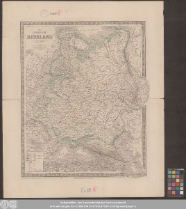
| dc.title | Das Europäische Russland | - |
| dc.type | Map | - |
| dc.identifier.urn | urn:nbn:de:gbv:3:3-1192015415-1729137520-12 | - |
| dc.identifier.shelfmark | Altkt B II 10 [7] 3 | - |
| local.openaccess | true | - |
| dc.identifier.ppn | 1729137520 | - |
| local.comment.extern | Koloriert | - |
| local.mets.uri | https://opendata.uni-halle.de/retrieve/812b22d0-a582-468e-b11c-78a3bb8fb34e/mets.xml | - |
| local.holding | Universitäts- und Landesbibliothek Sachsen-Anhalt | - |
| local.holding.displayform | Universitäts- und Landesbibliothek Sachsen-Anhalt, Altkt B II 10 [7] 3 | - |
| dc.contributor.cartographer | Gräf, Carl | - |
| dc.contributor.publisher | Geographisches Institut zu Weimar | - |
| dc.date.digitization | 2023 | - |
| dc.description.note | Nullmeridian: Paris | - |
| dc.description.note | Mit Randüberzeichnung | - |
| dc.description.note | Bergstriche | - |
| dc.description.note | Enthält 1 Nebenkarte von St. Petersburg und Umgebung | - |
| dc.description.note | Karte | - |
| cbs.contenttype.code | cri | - |
| cbs.contenttype.text | kartografisches Bild | - |
| cbs.digitization.displayform | Halle (Saale) : Universitäts- und Landesbibliothek Sachsen-Anhalt, 2023 | - |
| cbs.publication.displayform | Weimar : Geographisches Institut, 1857 | - |
| cbs.picatype | Aa | - |
| local.map.scale | 1:6 588 000 | - |
| local.map.scale_sort | 1:6588000 | - |
| local.map.coordinates | E 007 30 00-E 070 00 00/N 071 30 00-N 036 30 00 | - |
| local.publication.edition | Revidirt von C. Gräf 1857 | - |
| Appears in Collections: | Karten und Atlanten | |
Ressources:
 |
|